Environmental Projects
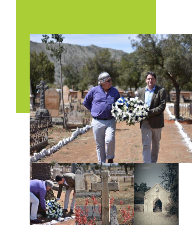
The Cemetary Project
Rehabilitation of Dutoitspan Cemetery during 2017 - 2018
“Paying respect to those who were once part of the mine”.
Sometimes incorrectly referred to as the "Chinese cemetery", the Dutoitspan cemetery is Kimberley's oldest official cemetery. However, it is likely there were older individual graves, or possibly clusters of graves, long gone from memory and sight. This cemetery’s condition has deteriorated over the years and had reached a general state of disrepair that was not indicative of the historical significance of this site. Vandalism and desecration of graves were widespread throughout the cemetery.
Ekapa initiated the cleaning and renovation of the Dutoitspan cemetery after taking ownership of the property. The project was launched at the beginning of June 2017 and was completed with a rededication on 26 September 2018. This project serves as the company's way of having a voice for those who are long gone and who made a huge contribution during their time living in the Kimberley area.
Regarding the history of the Dutoitspan cemetery, it was reported by The Diamonds News on 15 July 1871, the day before the discovery of the Big Hole, that there were at least 43 graves in the cemetery, of which 15 were those of children who had died of croup during that same month. Originally in the shape of a coffin, the cemetery was extended and reasonably well maintained up to the 1980s.
The cleaning of the graves in the cemetery involved removing all rubbish, trees, shrubs and grass. All gravestones were fixed in the upright position with specially designed equipment called a gantry and chain block, particularly those broken down over the years. During the years of neglect, many tailings and loose gravel washed into the cemetery. A vacuum suction truck, usually utilised in gold mines, was contracted from Afriveyor by Ekapa to clear and uncover lost and buried headstones.
Some of the individuals buried in this cemetery were pioneering members of the workforce in the mining fields of Dutoitspan and Bultfontein during the 1800s. Through their involvement in this project, the Ekapa Environmental team and Mine Management felt honoured and privileged to have been paying their respect to those and their families who were once part of the mine.
Carbon Capture Project
The South African Tailings for use in Carbon Capture and Storage (SAT4CCS) project, led by researchers from local universities and Oxford University, is an ambitious research project that aims at enlisting help from SA's vast tailings inventory in order to help them in the fight against climate change.
The research forms part of a local and global effort by scientists and private interest groups to help in avoiding global climate crises due to the continued rise of greenhouse gases (especially carbon dioxide) and advancing some of the key Sustainable Development Goals (SDG), especially the climate action goal.
Ekapa is one of the first mines to have heeded the call to form part of a consortium of mines to volunteer in collaborating with the research project by availing, to the researchers, access to tailings samples and nonproprietary data.
Rooifontein
BirdLife South Africa supports the management of the beautiful Rooifontein property located near Kimberley in the Northern Cape. This work includes monitoring projects and the development and implementation of a management plan.
BirdLife South Africa and other birders do regular bird monitoring (using the mobile app BirdLasser), and through the use of camera traps, mammals and other species are monitored. The management plan will set out objectives and activities which will guide conservation activities on the property. Other ad hoc projects include tracking the progress of rehabilitation projects using remote sensing.
BirdLife South Africa and other birders do regular bird monitoring (using the mobile app BirdLasser), and through the use of camera traps, mammals and other species are monitored. The management plan will set out objectives and activities which will guide conservation activities on the property. Other ad hoc projects include tracking the progress of rehabilitation projects using remote sensing.
Conservation Modeling Project
The Conservation Modelling Project develops cutting-edge research that enables us to assess and monitor the state of South Africa's ecosystems and habitats. By identifying core sites that form the base of resilient ecological networks, we enable conservation practitioners and land managers to develop and implement scientifically robust initiatives that promote positive change.
This project aims to create habitat suitability maps for all threatened and endemic species, including Rudd's, Botha's, Red and Barlow's Lark, Yellow-breasted Pipit, Southern Bald Ibis, Ludwig's Bustard, Lesser Flamingo, Black Stork and White-backed Vulture, among other species. The habitat suitability models created will provide a further understanding of the presence and state of threatened and endemic species hotspots, guide and direct our conservation efforts for threatened habitats and species, and promote sustainable development and representative conservation planning about avian species.
This project focuses on the Northern Cape Province, which hosts many highly specialised and range-restricted avian species. The globally threatened Red Lark is one such species that is entirely confined to specialised habitats within the Northern Cape province of South Africa. Unfortunately, the population trend, status, and actual distribution of many of these species are unknown.
Considering the potential impact of climate change on this arid environment and the recent swell in development across this region, gaps related to these species must effectively be filled to direct conservation initiatives.

Kamfers Dam
Kamfers Dam is a globally recognised Important Bird and Biodiversity Area. This site hosts numerous water birds, some of which are threatened, such as the Lesser and Greater Flamingo. A range of activities is performed, including:
- The monitoring of algal bloom levels through remote satellite sensing
- The establishment of a Site Support Group which will guide conservation efforts at the site
- Keeping track of the flamingo population over time
- Promoting tourism through the building of a viewing platform and erecting appropriate fencing
- The development of a Lesser Flamingo International Single Species Action Plan